Maps & Analysis created by MCC GIST Student Interns in Spring 2023
Pollinator Pathways | 27 Years of Change
Pollinator Pathways | 27 Years of Change
Pollinator Pathways project
Using NDVI and Survey 1-2-3 to identify natural corridors where pollinators can thrive
and areas where pollinators need more healthy, native vegetation to thrive.
The 2023 Survey 1-2-3 Form (now read only): https://arcg.is/0f0TLr
Using NDVI and Survey 1-2-3 to identify natural corridors where pollinators can thrive
and areas where pollinators need more healthy, native vegetation to thrive.
The 2023 Survey 1-2-3 Form (now read only): https://arcg.is/0f0TLr

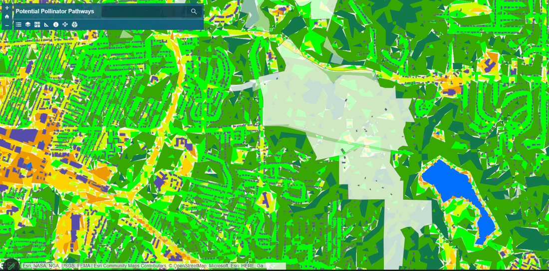
Detail from the Pollinator Pathways map hosted on ArcGIS Online. NDVI rasters were converted to vectors to improve speed.
"Pollinator Pathways"
Maps & analysis by Alexander LaBue, 2023 Student Intern, GIST Capstone Course, Monroe Community College
LinkedIn: www.linkedin.com/in/aj-labue-4983b7223
Portfolio: https://monroecc.digication.com/aj-labue/about-me/published Email: [email protected]
Maps & analysis by Alexander LaBue, 2023 Student Intern, GIST Capstone Course, Monroe Community College
LinkedIn: www.linkedin.com/in/aj-labue-4983b7223
Portfolio: https://monroecc.digication.com/aj-labue/about-me/published Email: [email protected]
27 Years of Change project
Using USGS NLCD Land Use Data and various local data sources to visualize changes from 1992 to 2019
in Land Use in Monroe County, NY
and in sites documented in the Preservation of Environmentally Sensitive Areas (PESA) Report from 1996 to 2023.
See the PESA Report & Photos on our FMCE PESA Page for historic details.
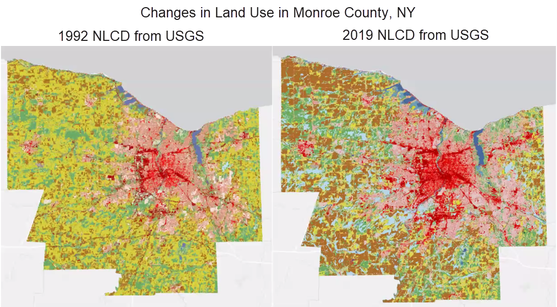
National Land Cover Database (NLCD) information: USGS recategorized and added some land use types in NCLD from 1992 to 2019. For these two maps, some categories were combined into more general categories, and the same colors selected, to enable a like comparison of land use over that span of time.
|
Land Use Change* in Monroe County, NY from 1992 to 2019
(a) Developed land (red-intensive, pink-moderate) increased approximately 10.9% (45,952 acres) (b) Fields (cultivated and meadows) decreased approximately 17.9% (77,204 acres) (c) Wetlands (which includes more categories in 2019) increased approximately 10% (42,581 acres) (d) Forest (greens) decreased approximately 3.5% (15,627 acres) (* as calculated in ESRI ArcPro from the combined & normalized categories of NLCD data) |
"27 Years of Change"
Maps & analysis by Martha Van Bork, 2023 Student Intern, GIST Capstone Course, Monroe Community College
Maps & analysis by Martha Van Bork, 2023 Student Intern, GIST Capstone Course, Monroe Community College
Banner Photo by Margaret Thurston.
